Newbury is the principal town of West Berkshire and also (within the area of the original borough) a civil parish. Through it runs the river Kennet, the Kennet & Avon Canal, the Great Western Railway line to Devon and Cornwall, and the A4 (formerly known as the Bath Road). The latter’s arterial function has now been superseded by the M4 motorway a few miles north of the town. From the 1880s until the 1960s north-south links were augmented by the Didcot, Newbury and Southampton Railway. The Newbury bypass (A34) opened on the west side of town in 1998.
The civil parish of Newbury consists today of the original town and acquired suburbs, several of which were separate parishes until 1878, when the northern and eastern town boundaries were extended to take in Speenhamland, Shaw and part of Donnington, Wood Speen, Church Speen and Greenham. The borough boundaries were extended again in 1934, taking land from Cold Ash, Thatcham and Enborne.
Hundred
Faircross
Poor Law Union
Newbury
Registration district
Newbury
Present-day local authority
West Berkshire (unitary authority) since 1998, replacing Newbury District Council.
Grid reference
SU 46 67
Adjoining parishes in 1851
Enborne, Speen, Shaw-cum-Donnington, Greenham, Thatcham, and (in Hants) Highclere, East Woodhay
Size
- in 1851: 1,242 acres (503 hectares)
- in 1924: 1,826 acres (740 hectares)
Population
1851: Newbury 6,568; Speen 3,295; Shaw 653; Greenham 1,182
2011: Newbury 41,553
Place names within Newbury
Bartholomew Street: the main route leading southwards from the town centre.
Cheap Street, one of the trio of town centre roads, leading southwards from the Market Place. It was severely truncated by the arrival of the railway in 1843, and again with the construction of the ring road in the 1960s.
The City: a group of streets south-west of the town centre, never a separate parish, but having a distinctive culture, which included election of its own mock mayor. Until the early nineteenth century it was known at St Bartholomew’s, and was at one time the site of St Bartholomew’s Fair. There are numerous almshouses in and near this area.
Donnington: a village north of the town, site of the Second Battle of Newbury (1644), during which the castle and much of the village was destroyed. The village contains a former priory and almshouses. The castle ruins remain Berkshire’s only stone castle apart from Windsor. See Shaw-cum-Donnington.
East and West Fields: former commons within Newbury town, enclosed in 1844, and now wholly built over.
Greenham: a separate village to the south-east of the town. Most of it was incorporated within Newbury 1878, but it is still a separate civil parish. Greenham Common (which occupies a large part of the parish) was commandeered for an airbase during the Second World War, and was occupied by the USAF from the 1950s until 1990.
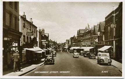
Northbrook Street: the main shopping street running north from the river Kennet towards Speenhamland.
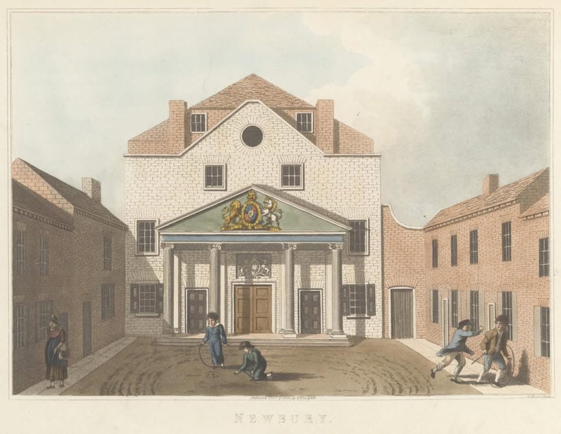
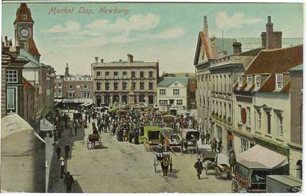
Market Place, a triangular space south of the river Kennet, where Newbury’s charter market has been held since medieval times. The town hall is also here.
Northcroft: a commons to the west of Newbury town, and still a grassy open space. It has long been the site of racing, fairs and festivals.
Sandleford: extra-parochial district on the south eastern edge of Newbury, 520 acres. Noted for Sandleford Priory, now a school.
Shaw-cum-Donnington: two parishes to the north and north east of the town centre, joined by 1839. Taken into Newbury in 1878, but still a separate civil parish.
Speen: a village to the north-west, partly incorporated into Newbury in 1878, but still a separate civil parish.
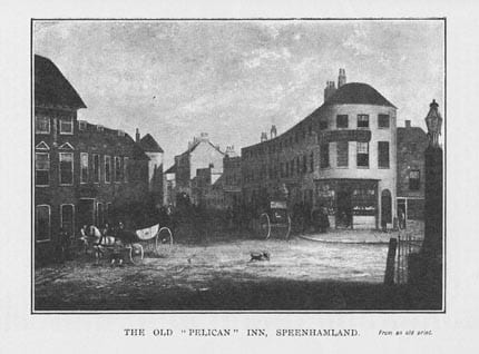
Speenhamland: on the northern edge of Newbury, bridging the gap between the town and Speen, and spanning the London/Bath road. It was the centre of Newbury’s coaching trade 1750 – 1850.
St Bartholomew’s: see the City.
Victoria Park: formerly town commons on the north bank of the Kennet, this area is now a public park with boating lake, bandstand and playground. Formerly called the Marsh, it was renamed in honour of Queen Victoria’s 1897 jubilee.
Wash Common: scene of the First Battle of Newbury in 1643, the Wash was around 450 acres of common land south of the town centre, divided between the parishes of Newbury and Enborne, and virtually uninhabited until the end of the nineteenth century. Newbury Wash was enclosed in 1858, and in 1934 the town boundary moved westwards to take in Enborne Wash. Wash Common is now wholly developed.
Wash Water is the name of the southern tip of Newbury, part of Wash Common, lying alongside the river Enborne. The name also covers part of Enborne.
Genealogical resources
For Greenham, Speen and Shaw-cum-Donnington parishes see under their separate entries.
See Berks FHS Books for coverage of this parish in the society’s range of CDs.
See also Berkshire Record Office holdings.
Other sources and links
- The local newspaper is the Newbury Weekly News, published since 1867. Microfilm copies back to that date can be seen in West Berks Library. (The NWN is not yet digitised.)
- West Berks Museum and West Berks Library cannot be directly linked from here, but they can be reached by going to West Berks Council and searching under Library and Museum.
- A Newbury bibliography can be seen on Phil Wood’s website.
- Friends of Newtown Road Cemetery
- St George’s and Wash Common
- St Nicolas’ Church
- St John the Evangelist Church
- Newbury Methodists
- Newbury Baptists
- St Mary’s Greenham
- St Mary’s Shaw
- St Joseph’s RC church Newbury
Anglican parochial organisation
Newbury is an Anglican deanery, under the archdeaconry of Berkshire, within (since 1836) the diocese of Oxford. Before 1836 it belonged to the diocese of Salisbury.
Anglican churches
See under Links on page 2 for individual church websites.
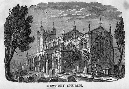
St Nicolas, Newbury’s town parish church, built at the beginning of the sixteenth century. It has a churchyard, part of which was dismantled and used to build a church hall in the 1980s.
St John the Evangelist is a 1950s building of red brick, sited at a major road junction south of the town centre. It replaced a Victorian predecessor destroyed by enemy action in 1943.
St Mary, Greenham, dates mostly from 1875-76, when Victorian renovation obliterated a much older chapel.
St Mary the Virgin, Shaw-cum-Donnington, was built in 1840-42, replacing a church of great antiquity.
St Mary the Virgin, Speen, was renovated in mid-Victorian times, but has interesting monuments going back to the early eighteenth century.
St Mary, Speenhamland, was built in 1830 on the London Road. It was demolished in 1976.
St George the Martyr, Wash Common, was begun in 1933 and completed in 1965, replacing the tiny mission church of St Luke’s which had served Wash Common since the late nineteenth century (and which still stands as a theatre). The parish was carved out from those of Enborne and St John. It has no churchyard.
Other churches
The Roman Catholic church of St Joseph dates from 1928, but its predecessor of 1864 still stands alongside. There was a mission in the town before 1864. In 1968 the Catholic parish of St Francis de Sales was formed in Wash Common, and a church was opened in 1970.
In 1697 the Presbyterians built the Lower Meeting House on the north bank of the river, east of Northbrook Street. In 1924 this chapel was recorded as mainly Unitarian. It was pulled down in 1960.
The Independents, as they were at first known, built their first chapel in Newbury in 1717, known as the Upper Meeting House. The present URC church (Congregational until 1972) in Cromwell Place was built around 1960, replacing a church of 1822.
By 1669, and probably before, there was a very small Baptist congregation at Newbury, which licensed a new meeting house in Northcroft Lane in 1702. The Baptist church of 1859 in Northbrook St was demolished in the 1930s, and replaced with a new building in Cheap St.
The first Methodist chapel was in Wharf Road. The present Wesleyan chapel was built in 1838 in Northbrook St and still stands. In the mid-nineteenth century it had a school attached. Stroud Green, in Greenham also had a Methodist chapel at one time. Primitive Methodists were active in Newbury from 1830, but did not have a chapel until about 1887; it was demolished after gale damage in the 1940s. A Primitive Methodist chapel which opened in Wash Common in 1844 lay (technically) in Enborne until the boundary move of 1934 brought it into Newbury. The chapel was demolished in 1990, but a plaque marks the spot.
Newbury’s original Quaker meeting house stood in Bartholomew St, later moving to Highfield Avenue, behind the bus station, and near the old burial ground site. The area is likely to undergo redevelopment soon.
Other local history
Newbury grew from the Domesday manor of Ulvritone in the eleventh century, developing from an important trading crossroads. By the time of the town’s first charter, granted in 1596, the town was already at the peak of its prosperity, based on the cloth trade and personified by the families of Jack O’Newbury (also known as Jack Winchcombe and Jack Smallwood) and Thomas Dolman. In 1627 the manorial lordship of the town was granted to the corporation from the Crown. The cloth trade was by this date in decline, although textile production continued until the industrial revolution. Corn was another staple of the town’s trade; in the early nineteenth century Newbury’s corn market was larger than that of Reading.
The market place, the river bridge and Northbrook Street constituted the business centre of the town, although the coaching trade (from roughly 1750 to 1850) granted a century of prosperity to Speenhamland at the north end of town, through which the Bath Road passed. As early as 1752 some 34 coaches plied daily along the London Road.
In 1714 the river Kennet was made navigable to Reading, and much of Newbury’s goods traffic with London was shipped through Reading by barge. By 1810 the Kennet and Avon Canal connected Newbury and Bath.
The arrival of the railway in the 1840s ended both the coach and canal trades. Nonetheless Newbury’s population burgeoned, and in 1846 about 214 acres of the commons of East and West Fields were enclosed. Many of the Victorian workers’ terraces then built are still standing. In 1855-58 the Newbury side of Wash Common was enclosed, but building here was slower, with the last vestiges of the common not disappearing until the 1970s.
Newbury today is well-known for tech businesses, and for its racecourse, actually located in the parish of Greenham. The charter market is held every Thursday, and there is an additional market on Saturdays. In recent decades Newbury achieved national fame for two enduring protests: the first against cruise missiles at RAF Greenham (1981-90), and the second against the building of the Newbury bypass (1996-97).
 Wash Common WM
by Margaret Young
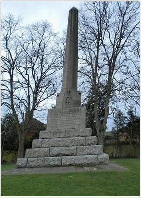
The Falkland Memorial was erected in the 19th century to commemorate Lucius Cary, 2nd Viscount Falkland, who fell at the First Battle of Newbury in 1643. The memorial is situated at the junction of Andover Road, Essex Street and Monks Lane in Wash Common.
OS ref: SU459649
