Warfield village is a civil and ecclesiastical parish in the Thames Valley in the east of Berkshire and in the borough of Bracknell Forest, about 12 miles east of Reading and 6 miles south-west of Windsor. “Ye Towne and Pish of Warfield” was a mediaeval description of this part of Berkshire. (‘Pish’ being short for parish and ‘towne’ obviously having a different meaning to today.) Various suggestions have been made as to the origin of the name Warfield, the general conclusion is that it was not named as a field of battle. The ‘war’ part of the name is thought to derive from the Anglo-Saxon word for the bird, the wren. The parish is about 3.5 miles from north to south and two miles east to west. Back in Anglo-Saxon times, and for centuries later the parish was part of the Royal hunting grounds of Windsor Forest. When William the Conqueror became the owner of the Royal hunting grounds the parish of Warfield was given to Geoffrey de Mandeville as part of the Hundred of Wargrave.
The local geology – clay soil with patches of gravel – encouraged isolated farms in clearings in the forest which grew into scattered hamlets rather than a nucleated settlement. Today these have evolved into the communities of Brockhill, Haley Green, Jealotts Hill, Moss End, Newell Green and Nuptown. Bracknell was originally another of Warfield’s scattered communities located at the southern end of the parish.
In 1851 Bracknell became a parish in its own right, with land being taken from Warfield, Winkfield and Easthampstead parishes. By then it was the centre of commercial activity in Warfield parish with shops and, from 1870, a market. A century later Bracknell was designated as one of the post WWII NewTowns and its development has subsumed (and continues to subsume) land from its neighbouring parishes.
Archaeology
The parish has few recorded relics of ancient times. An arrow-head of the late Neolithic period was found at Jealott’s Hill. Post holes of an Iron Age roundhouse have been excavated at Newell Green. Part of a mediaeval moat protecting the isolated household still exists at Haley Green Farm.
Transport
No major roads go through the parish, but two ancient routes run roughly east / west across the parish. The more northerly one, Forest Road, ran between Reading and Windsor. Towards the southern end of the parish is the road between Reading and Virginia Water. This included Bracknell Street, Warfield (to become Bracknell High Street after 1850) around which New Bracknell developed. In the eighteenth century both roads became turnpike roads.
Local names
A number of family names found in old documents and parish records from years ago remain prevalent in the village today – Brant, Gough, Wise, Bowyer (found as far back as the 1500s), Hatfield, Sergeant and Cotterell.
Local place names
On Norden’s 1607 map of Windsor Forest there were just three places named within Warfield parish: Nupton Green in the north and New Bracknell and Old Bracknell in the south.
Roque’s 1761 map of Berkshire has the the following place names within Warfield parish: Bracknell, Brockhill, Edmund Green, Haly Green, Nemmell Green, Priestwood Common, and Upton Green.
Today we have Brockhill, Haley Green, Jealotts Hill, Moss End, Newell Green (named after Sir Henry Newell who is shown on the 1607 map as responsible for the Warfield Walke part of Windsor Forest) Nuptown (corrupted from Nupton Green), Warfield Park and West End. Additionally named within Warfield parish are new Bracknell development areas, including Quelm Park, and Whitegrove. Priestwood was the first housing estate to be developed in Bracknell New Town on the former Priestwood Common.
Links
The Victoria History of the Counties of England – Berkshire (https://www.british-history.ac.uk/vch/berks/vol3/pp184-191)
Published local history
Eileen Shorland – “The Pish (Parish) of Warfield and Easthampstead which includes Old Bracknell”, originally self-published by Eileen Shorland in 1967 with the 1980 edition being published by Warfield Parish Council.
Michael Banyard – “Warfield A Berkshire Village Between the Wars“, published by Roselle Publishing (2000)
Hugh Barty-King – “Warfield A Thousand Years of a Berkshire Parish”, published by Warfield Parish Council (2001)
Dr Michael Dumbleton – “Brickmaking: A Local Industry”, published by Bracknell and District Historical Society (1978; revised 1990)
Anglican church and parochial organisation
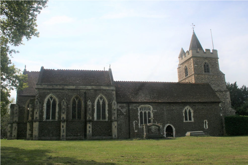
The parish is in the Archdeaconry of Reading in the Diocese of Oxford and the church is dedicated to St Michael the Archangel. It is believed that Warfield’s first place of worship was built around AD900 as a wooden church. When William the Conqueror became King, the parish of Warfield was given to Geoffrey de Mandeville as part of the Hundred of Wargrave. Geoffrey de Mandeville built a monastery, Hurley Priory, which was funded by monies from parishes within the Hundred of Wargrave, including Warfield.
The Prior of Hurley became Patron of Warfield with responsibility to appoint its Rector. From time to time the monks at Hurley moved to Warfield when Hurley was flooded by the Thames. The Warfield-Hurley link lasted until Henry VIII’s dissolution of the monasteries. It is understood that during the time that the Hurley monks spent at Warfield, amongst other things they constructed fish ponds in the stream near the church as a source of food.
The 11th century stone church was dedicated to St Michael, the Archangel. The original stone building was enlarged in the 14th and 15th centuries to become the building we see today. No good road served the church so it was isolated, with only the vicarage and two other houses close by (all the present houses around it are 20th century buildings).
Other churches
In 1822 a Congregational Chapel was built in Bracknell Street, Warfield. There was a ‘Tin Chapel’ at Moss End. In 1909 an ‘evangelical’ Gospel Hall was built in Warfield Street.
Schools
A school was built in 1816 on waste land given for the purpose of ‘the voluntary education of poor infants’. It was not in an ideal position as it was on the edge of the parish, between Haley Green and Brockhill, distant from the northern end of the parish and almost three miles from Bracknell. It became Warfield School, rebuilt in the 1870s, and served much of the parish along with Bullbrook school (or The Bracknell school as it was first called). Priestwood school was built early in the twentieth century. Warfield School survived until the 1990s when it was replaced by a newly built school as part of new Bracknell developments.
Pubs
There were seven public houses in Warfield between the world wars and six others outside the parish, but within easy walking distance. Those in Warfield were the Cricketers, the Four Horseshoes, the New Leathern Bottle, the Plough and Harrow, the Shepherd’s House, and the New Inn (what was to later become the Three-Legged Cross – now the The Spice Lounge). Today (2023) just the Cricketers, the Plough and Harrow, and the Shepherd’s House remain.
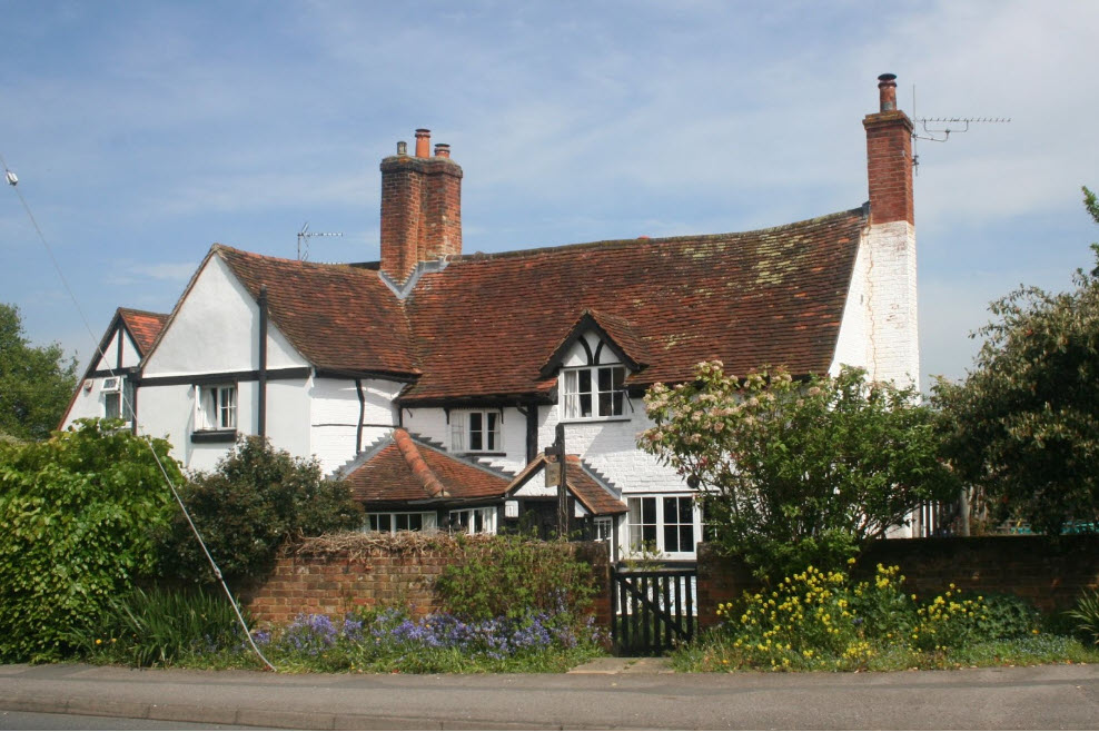
The Four Horseshoes was the oldest and probably had the most interesting history. Originally simply known as the Horseshoes,it was a convenient stopping place for drovers on the Forest Road about twelve miles from Reading, as there was a wide green for grazing cattle. It was also a coaching inn (the stables were only demolished in 1962). As the church had no convenient meeting hall the Horseshoes became the parish meeting place with vestry meetings being held in the building behind the pub. (Today the original pub is a private house, Horseshoe House.)
Other local history
For centuries there have been a number of small estates with elegant houses in the parish, but no notable ‘lord of the manor’ brought particular fame to the district. Between the two World Wars there were four large mansions (of which three remain) and some fifteen smaller country houses. The proximity of the court at Windsor (6 miles away) and London probably account for the concentration of the upper classes.
The Victoria History of the Counties of England – Berkshire notes “The occupation of the inhabitants is mainly agricultural, but there are brick-yards and a large wheelwright’s business in the parish.”
During the latter half of the nineteenth century and the first half of the twentieth century brick-making was an important industry in east Berkshire taking advantage of local clay deposits, some of particularly fine quality. An important brickmaking company was Thomas Lawrence and Sons. Thomas Lawrence purchased the clay deposits in Gough’s Lane, Warfield in about 1860. Lawrence’s circular of 1893 shows that by then they had works at Swinley, Easthampstead, Warfield and Pinewood and were making 12 million bricks per year, with their T.L.B. (Thomas Lawrence, Bracknell) trademark. T.L.B. bricks were used in buildings in many parts of the UK and abroad. Notable buildings built using them included Westminster Cathedral, Royal Holloway College, and Madame Tussauds. Although the other works had closed over the years Lawrence’s Warfield works continued in production until the late 1980s making award-winning hand-made facing and specialist gauged bricks for window heads and arches. The closure of Lawrence’s Warfield works brought an end to brickmaking in the area.
The wheelwright’s business was Bowyer and Son, which in the early 1900s had existed for over a century and the last carriage was worked on in the 1950s. Bowyer’s made a wide range of wheeled vehicles including four-wheeled farm and timber wagons, two-wheeled farm carts, vans and delivery vehicles for commercial merchants and carriages and governess cars for the larger houses in the area.
Once Bracknell was created as an ecclesiastical parish in 1851 it became more urbanised, while Warfield remained mainly agricultural. An area of the land at the northern end of Warfield, however changed from basic food production when, after the end of WWI, the newly formed ICI bought Jealott’s Hill Farm as a centre for agricultural research and demonstration. ICI’s influence expanded over the years with the fields of Moss End and Malt Hill farms and others in the area being used on a short term basis (often for just one crop) latterly under the name of Syngenta.
