Harwell is an ecclesiastical and civil parish in the Vale of the White Horse, about three miles south-west of Didcot, formerly in northern Berkshire, but relocated since 1974 in Oxfordshire. It lies within the North Wessex Downs Area of Outstanding Natural Beauty.
Place names from the 1851 census include: Barrow Lane, Broadway, Bustard Lane containing Crispin Farm, Chetwood Farm, Church Lane, Downs Farm, Folly House, Hall’s Farm, Ham Farm, Harris’ Yard, Hopkins Farm, Hunt’s Yard, King’s Lane, London Road, Mouses Hole, Rowstock Cottage, School Lane, Talbot’s Lane, Twitchers, Vinigar Lane, Wells Head Lane and Farm.
Size
2,521 acres (1,021 hectares)
Population
884 in 1851; 1,998 in 2011
Hundred
Moreton
Poor Law union
Wantage
Registration district
Wantage
Present-day local authority
Vale of the White Horse district, Oxfordshire County Council
Grid reference
SU 49 89
Adjoining parishes in 1851
Chilton, Didcot, East Hagbourne, East Hendred, Milton, Sutton Courtenay
Genealogical resources
See Berks FHS Books for coverage of this parish in the society’s range of CDs.
See also Berkshire Record Office holdings.
Links
The parish council site has some historical photos.
Published local history
Nick J Hance Harwell from Romans and runways to reactors and research renaissance (Enhance Publishing, 2006)
Anglican church and parochial organisation
Harwell is a vicarage in the diocese of Oxford. The parish church of St Matthew is possibly twelfth-century.
Other churches
A Wesleyan chapel was recorded in 1868.
Schools
Provision for a charity school was made in the will of Robert Loder in 1644; 12 poor boys (later increased to 25) were to receive instruction in reading, writing and arithmetic.
A National school existed in (and possibly before) 1868, and was probably the foreunner of today’s primary school.
Pubs
Harwell used to have five pubs and a brewery. The Crown, enumerated in the 1851 census, was converted to a nursing home. The Chequers, enumerated in 1851, and the Queen’s Arms (which became the Kicking Donkey in the late nineteenth century) have both been converted to private housing. The Crispin has also closed. Only the White Hart, also enumerated in 1851, continues in business as the Hart of Harwell.
Other local history
The Harwell area has long been known for cherry-growing. The Old Cherry Barn is believed to date back to 1200. Cherry Teas were held in the eighteenth century. The former cherry orchards later became owned by Grove Farms.
RAF Harwell was built between Harwell and Chilton In 1937. After the Second World War the RAF station became the home of the Atomic Engergy Research Establishment, researching nuclear power under the aegis of the UK Atomic Energy Authority. Later it became known as Harwell Laboratory, and eventually, with the wind-down of nuclear research in the 1980s, the site has become a science and innovation business park, managed by an Australian property company.
Post-war, the local population expanded considerably with the Harwell Laboratory.
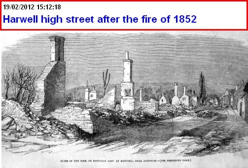
Harwell high street was the scene of a disastrous fire in April 1852, in which 55 buildings were destroyed. The event was written up in the Berkshire Chronicle, and in the Illustrated London News, including the illustration below.